October 7th, 2020
Key Findings
- GFDL has developed a unified “one code, one executable, one workflow” global prediction modeling system, called SHiELD.
- SHiELD’s multiple configurations show prediction skill and simulation fidelity matching or exceeding those of existing weather forecast models.
- The FV3 Dynamical Core provides a powerful foundation for unified prediction modeling.
Lucas Harris, Linjiong Zhou, Shian-Jiann Lin, Jan-Huey Chen, Xi Chen, Kun Gao, Matthew Morin, Shannon Rees, Yongqiang Sun, Mingjing Tong, Baoqiang Xiang, Morris Bender, Rusty Benson, Kai-Yuan Cheng, Spencer Clark, Oliver Elbert, Andrew Hazelton, J. Jacob Huff, Alex Kaltenbaugh, Zhi Liang, Timothy Marchok, Hyeyum Hailey Shin and William Stern. Journal of Advances in Modeling the Earth System. DOI: 10.1029/2020MS002223
At many weather forecasting centers, different computer weather models are run for different applications. In the U.S., there are separate models for short-range, long-range, seasonal, and hurricane forecasting. Each specialized model is designed by different experts to get the best results. However, having separate models multiplies the effort needed to maintain and upgrade each model, and makes it difficult to move improvements from one model to another.
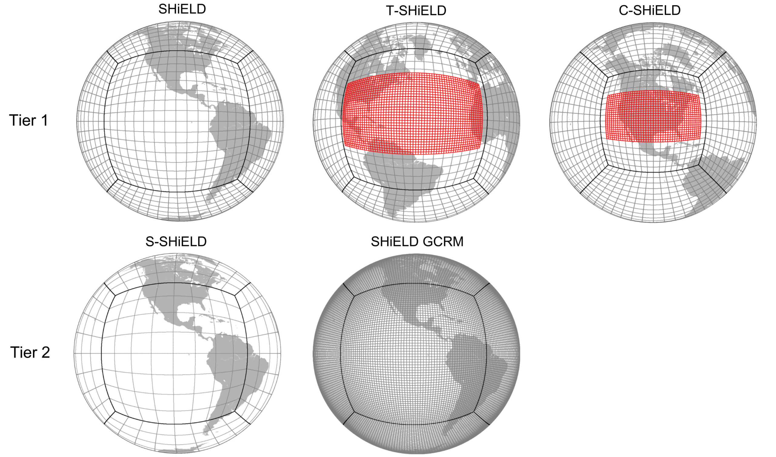
GFDL scientists have developed a new “unified” weather modeling system, the System for High-Resolution Prediction on Earth-to-Local Domains (SHiELD), which can be configured for a variety of applications. SHiELD links together a variety of applications— high-resolution short-range (0–60 hour), global medium-range (2–10 days), hurricane, and subseasonal (10–40 days) forecast models—in the same modeling system. This reduces the effort to implement and maintain such systems. Five separate modeling systems are replaced by one. In addition, this enables transfer of innovations and advances between forecast models, facilitating a truly seamless atmospheric modeling system. This system makes heavy use of variable-resolution global modeling, allowing a global model to efficiently zoom-in over regions of interest, so that forecasts of extreme weather that are currently limited to 1–2 days of lead time can be extended into the medium range and beyond.
SHiELD uses a powerful computer code, FV3, to compute the fluid motion of the atmosphere at any size and any length of time, with the ability to zoom in on the Contiguous US, tropical oceans, or other areas of interest to better “see” severe storms or intense hurricanes. The authors started from a model developed to test an FV3-based model in a realistic forecasting environment, and over time, gradually improved the representation of different atmospheric features (clouds, turbulence, mixing), then expanded into new uses for the system, including short-range severe thunderstorm prediction, hurricane forecasting, and weather forecasts as long as six weeks in the future. Since many of the components of SHiELD are used by models being developed by the National Weather Service for use by weather forecasters, the advances described in this paper can be rapidly introduced into those models, eventually improving official forecasts.
This work validates the feasibility and potential benefits of building a unified weather prediction system to serve many of NOAA’s current prediction needs, and in particular demonstrates a concrete implementation of the Unified Forecast System (UFS) using the same components being used to build UFS. Further, it demonstrates the value of exchanging advances between SHiELD and other UFS configurations, and with other modeling systems based on the GFDL FV3 Dynamical Core.
The authors are looking towards closer integration with GFDL climate models to extend towards a truly seamless “minutes-to-millennia” modeling system. They are also working to develop a native SHiELD data-assimilation cycling system able to take advantage of new advances within FV3 and the SHiELD physics to produce the most skillful forecasts possible, rather than relying on analyses from operational centers to initialize SHiELD.
Real-time forecasts are available at shield.gfdl.noaa.gov.