February 7th, 2018
Key Findings
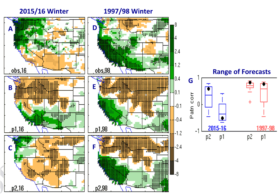
- Ocean initialization only: The FLOR model, with only the ocean component initialized by observations, fails to predict the observed precipitation pattern over the WUS during the 2015/16 winter. In contrast, during the 1997/98 winter, the ENSO-teleconnected variations dominated the local climate anomalies over the WUS with the skillful prediction mainly arising from the ocean initial conditions.
- Enhanced initialization with ocean, atmosphere and land components: The FLOR model, with ocean, atmosphere and land components initialized by observations, largely predicts the 2015/16 observed pattern over the WUS.
- Enhanced initialization also improves the 1997/98 predictions and predictions for all winters tested (1982-2016).
X. Yang, L. Jia, S.B. Kapnick, T.L. Delworth, G.A. Vecchi, R. Gudgel, S.D. Underwood, F. Zeng. Climate Dynamics. DOI: 10.1007/s00382-018-4109-3
There has been an increasing call for better seasonal precipitation prediction systems to support water resource management, particularly over regions like the western United States, where a multi-year drought persisted from 2012-2016. This research addresses the challenge of building a better prediction system by exploring the extent to which this past winter’s western U.S. precipitation anomalies may have been predictable, using experimental retrospective forecasts with GFDL’s Forecast-Oriented Low Resolution (FLOR) model. The authors found that when the model was initialized with ocean, atmosphere, and land states, it largely predicts the 2015/16 observed pattern over the western U.S.
During the 2015/16-winter season, a strong El Niño developed over the tropical Pacific. A wintertime precipitation pattern like the historically extreme 1997/98 El Niño with wet conditions over a parched Southern California and dryer conditions further north was expected, and predicted by most operational prediction models. However, the actual observed 2015/16-precipitation pattern was virtually the opposite.
The authors used the 2015/16 winter as a case study, employing two different initialization setups in the model to test the prediction skill generated by each initialization method. One method initialized only the ocean; the other method initialized the ocean, atmosphere, and the land. The results highlight the importance of initialization and the substantial impact of intrinsic noise in controlling western U.S. regional precipitation anomalies. Even under the broad influence of a global-scale El Niño—thought to be the paramount, baseline initial state required for prediction — predictions can be influenced by the improved initialization of the atmosphere and land. .
The model with only the ocean component initialized (by observations) fails to predict the observed precipitation pattern over the western U.S. during the 2015/16 winter. In contrast, during the 1997/98 winter, the ENSO-teleconnected variations dominated the local climate anomalies over the western U.S., so that skillful prediction was achieved, mainly because of the dominant role the ocean plays under these conditions.
The model initialized with ocean, atmosphere, and land components skillfully predicts the 2015/16 observed pattern over the western U.S. and this enhanced initialization also improves the 1997/98 predictions, as well as predictions for all winters tested (1982-2016). Although the skillful predictive window with the added atmospheric and land components initialized is within one season in advance (3 months), this would provide additional climate information for short-term water resource management.
The global climate model used for these experiments, GFDL-FLOR, has 50-km atmospheric/land components coupled to a 100-km ocean. Developed for research, it is also used in the real-time experimental forecasts for NOAA’s North American Multi-Model Ensemble, an experimental multi-model seasonal forecasting system consisting of coupled models from multiple U.S. and Canadian modeling centers.