January 28th, 2014
Key Findings
- Basal resistance at the glacier-bedrock interface controls flow of the glaciers, and determines the rate at which ice is discharged from the interior of the Antarctic Ice Sheet to the ocean, hence determining the rate at which glaciers contribute to sea level.
- The basal traction underneath these glaciers has organized spatial patterns that imply complex interactions of glacier flow, subglacial water and deformable sediments, which can potentially change over decades to centuries both, due to internal ice-sheet dynamics and in response to climate change.
Olga V. Sergienko and Richard C. A. Hindmarsh. Journal: Science 342(6162). DOI: 10.1126/science.1243903.
Summary
This study advances our understanding of the physical processes controlling the dynamics of ice streams – pathways for ice discharge from the interior of ice sheets to surrounding oceans – and the leading source of uncertainty in projections of global sea level rise in the 21st century.
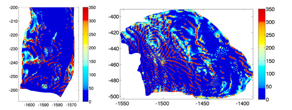
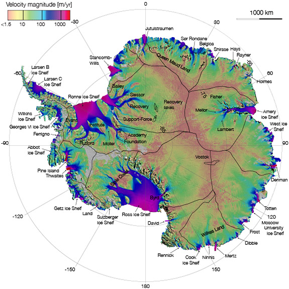
Direct observations of the conditions underneath thousands of meters of ice over extensive areas underneath the ice streams are practically impossible. Using recently-released high-resolution data sets and sophisticated inverse-modeling techniques, the authors compute the basal shear distributions for Pine Island and Thwaites glaciers in Antarctica. These two glaciers are losing mass at an accelerating rate and, despite their relatively small areas, are the major Antarctic contributors to sea level.
The inverse model utilized high-resolution data sets of satellite and airborne collected observations of the glaciers geometry and flow. The inversions reveal that the basal traction underneath these glaciers has organized spatial patterns such that narrow, rib-like structures with very high basal shear stress are embedded in much larger areas with zero basal shear. Such an organized spatial pattern implies that it arises from the complex interactions of glacier flow, subglacial water and deformable sediments.
The collocation of these high-basal shear ribs with highs in the gradient of hydraulic potential suggests that subglacial water controls evolution of these ribs. The authors theorize that the basal traction ribs arise from the long-term evolution of dynamic instabilities, manifesting themselves as bed-friction variation arising from variations in the effective pressure (the difference between ice overburden and subglacial water pressure) in space.
The presence of such rib-like spatial patterns in the basal shear of these fast flowing glaciers has implications for stability of their grounding lines. Both glaciers have inland-sloping over-deepened beds. The grounding lines in such geometric configurations are thought to be inherently unstable. There is a possibility of their temporal and spatial variability through, for instance, flooding of some of these ribs and reduction of their basal shear stress, that would lead to enhanced ice discharge into the ocean.
The present spatial configuration of basal resistance in these ice streams is not immutable and can potentially change over decades to centuries in response to changes to ice-sheet geometry or water input. Changes in basal shear stress distributions in the vicinity of the grounding line inevitably cause variations in ice flow and its flux through the grounding line, triggering its migration, with consequent changes in ice discharge to the ocean, and the glaciers’ contribution to sea level.