

Challenges in modeling the cloud-climate interactions?
Cloud processes span a large range of scales from sub-micrometer (CCN) to 1000s of kilometers (cloud-system). This range of scales cannot be explicitly resolved with numerical models for the foreseeable future. Cloud processes also involve many complex interactions among cloud microphysics, precipitation, moist turbulence, latent heat release, circulation, and radiation. The representation of moist turbulence and cloud microphysics are especially challenging in GCMs without detailed knowledge of the sub-grid scale turbulence statistics. There are many cloud regimes coexisting in the globe, reflecting diverse meteorological environment (e.g., shallow/deep, liquid/ice, ascent/descent, ocean/land, low/middle/high latitude or altitude, day/night, flat/mountainous, …). The processes and their interplay often differ significantly between regimes, making a unified representation especially difficult. The wide variety of cloud regimes are all likely important to the overall Earth radiation budget and need to be accounted for accurately. The above challenges also apply to theories and observations. Thus, a comprehensive modelling and observational strategy in combination withe theories is necessary to advance our understanding.
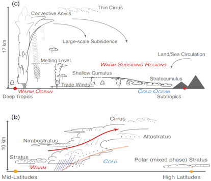
Figure: from the IPCC AR5 report (Chapter 7, Fig.7.4b-c): Upper: schematic of a vertical section in a trade wind flow from a subtropical continental west coast to the ITCZ. Cloud regimes include stratocumulus, shallow cumulus, and a transition to a precipitating cumulonimbus cloud system. Lower: schematic of a vertical section through a typical warm front of an extratropical cyclone. Cloud regimes include multiple layers of upper-tropospheric ice (cirrus) and mid-tropospheric water (altostratus) clouds in the upper-tropospheric outflow from the frontal zone, an extensive region of nimbostratus associated with frontal uplift and turbulence-driven stratus clouds.