

June 30th, 2025
Key Findings
- Over the past four decades, winter atmospheric rivers (ARs) have exhibited contrasting trends across the U.S.—a decline in activity over the western U.S. (WUS) has contributed to regional drying, while an increase over the eastern U.S. (EUS) has led to a wetter climate.
- These opposing trends are linked to large-scale atmospheric and oceanic variability in the Pacific, which intensifies anticyclonic circulation patterns near both coasts. These patterns tend to impede ARs from reaching the WUS while promoting their development over the EUS.
- The study provides a unified explanation for the observed long-term AR behavior in both regions, with significant implications for water resource planning and the mitigation of AR-related extreme weather events in densely populated coastal areas.
Wenhao Dong, Ming Zhao, Zhihong Tan, V. Ramaswamy. Nature npj Climate and Atmospheric Science. DOI: 10.1038/s41612-025-00998-x
Winter atmospheric rivers (ARs) are crucial for water supply and extreme weather events in both the western (WUS) and eastern United States (EUS), yet their long-term trends and interactions remain unclear. The authors address this by analyzing multiple observational AR datasets spanning the past four decades. They identified contrasting yet interrelated trends in AR frequency, intensity, and associated mean precipitation, and explain these trends based on large-scale atmospheric and oceanic variability in the Pacific. Their findings offer a unified explanation for the observed AR trends and carry important implications for mitigating risks related to AR-induced extreme events in both densely populated coastal regions.
ARs, typically thousands of kilometers long and hundreds of kilometers wide, are capable of transporting vast amounts of water vapor poleward. The WUS, in particular, is highly susceptible to ARs, as they exhibit remarkable efficiency in delivering significant precipitation when they are forced upward by mountainous terrain. The related heavy rainfall, snowfall, and associated floods, especially during winter, have been the subject of extensive research, focusing on their impacts on downstream water resources and associated hazardous weather events across different time scales. This study identified and analyzed key aspects of historical atmospheric river (AR) trends over both the western and eastern United States, along with associated precipitation and extreme precipitation, using multiple reanalysis datasets and a statistical modeling approach.
The authors unveil contrasting trends in wintertime AR frequency and intensity over WUS and EUS during 1980–2020. More frequent and intense ARs are observed over EUS, while WUS experiences a decreasing trend in AR frequency and intensity. When further categorized into different intensity levels using a simplified AR scale, the increased AR frequency over EUS can be primarily attributed to strong AR events, particularly those classified as exceptional. In contrast, ARs across all intensity levels examined here exhibit decreasing trends over WUS, although these trends are generally weak.
In addition, the authors show that more than 60% of extreme precipitation events are associated with ARs over WUS, with a fraction larger than 80% across much of California and the coastal zones of Washington. For EUS, over 70% of extreme precipitation events were concurrent with an AR. The increasing AR activity in EUS brings more extreme rainfall. This observed evidence is consistent with the conclusion drawn from previous modeling studies that climate change is likely to increase the risk of extreme precipitation events along the Pacific coast of the US.
The observed disparities in AR frequency trends are found to be linked to a consistent change in large-scale circulation pattern, which could be understood through changes in various climate modes. A stepwise regression analysis highlights the predominant roles of the Pacific North American Pattern, East Asian Subtropical Jet, and El Niño/Southern Oscillation indices, each exerting influence over distinct regions. Over the analysis period, all these climate modes exhibit a declining trend. As these indices decrease, corresponding anomalous anticyclonic circulation patterns appear near both the West and East Coasts, albeit with opposing effects due to their different relative locations. The anomalous anticyclonic circulation over the northeastern Pacific facilitates the southward advection of cold and dry air from the north and inhibits the eastward propagation of ARs into the region. Conversely, the anomalous anticyclonic circulation pattern south of the southeast U.S. enhances the northward propagation of warm and moist air from the Gulf of Mexico and the Atlantic, creating favorable conditions for AR development over EUS.
As ARs have profound environmental and socioeconomic impacts, this effort to analyze and understand historical atmospheric river (AR) trends contributes to improved future forecasts, safeguarding lives and property, and supporting a resilient economy.
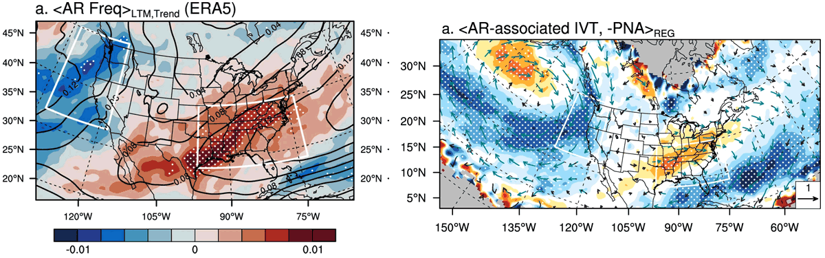
(Right): Regression maps of AR-associated IVT (units: kg m⁻¹ s⁻¹) with the PNA pattern. The PNA index is multiplied by –1 to account for its recent decreasing trend. Vectors represent the regression results of the zonal and meridional IVT components, while shading indicates the regression of IVT magnitude. White dots and green arrows denote statistically significant regressions at the 95% confidence level. Gray shading indicates regions where AR frequency data are not available.