December 5th, 2017
Key findings:
- This research investigated how historical land use and land cover change influenced regional climate extremes of temperature and humidity.
- The change of near-surface temperatures in GFDL’s earth system model (ESM2G) in response to deforestation is consistent with recent observations; in mid-latitude summers, crops and pastures are slightly warmer than nearby native forests.
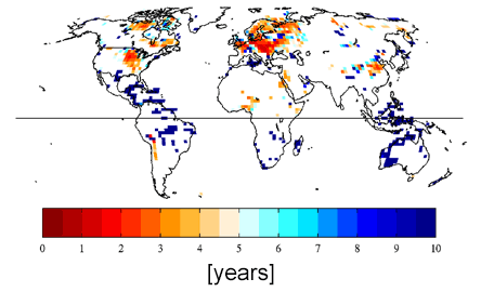
- Conversion of deciduous forests to crops and pastures has led to a 2 to 4-fold increase in the occurrence of hot, dry summers in altered regions of the upper central U.S. and central Europe.
Kirsten L. Findell, Alexis Berg, Pierre Gentine, John P. Krasting, Benjamin R. Lintner, Sergey Malyshev, Joseph A. Santanello Jr., Elena Shevliakova. Nature Communications.
Land surface processes modulate the severity of heat waves, droughts, and other weather extreme events. Vegetation and surface moisture conditions have been shown to impact both the severity and duration of heat wave events, as well as future aridity over land. An earth system model, GFDL’s ESM2G, was used to investigate the regional impacts of historical anthropogenic land use/land cover change (LULCC) on combined extremes of temperature and humidity. The authors show that conversion of forests to cropland has contributed to much of the upper central U.S. and central Europe experiencing extreme hot, dry summers every 2-3 years instead of every 10 years.
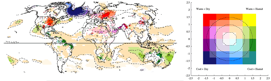
Assessing temperature and humidity offers a more complete measure of global change in extremes, as both are central to human experience of near-surface climate conditions. This work highlights the importance of vegetation cover and land use practices for regional climate extremes.