March 23rd, 2015
Key Findings
- The character of ENSO (El Niño and La Niña) varies substantially from event to event and decade to decade, especially for warm events (El Niños).
- El Niño events of all types are often preceded by westerly wind events in the western equatorial Pacific. Stronger El Niños typically involve a greater role for subsurface motions of the equatorial thermocline, and generate climatic anomalies that extend farther to the east.
- At present, forecast models can distinguish ENSO flavors up to six months in advance.
- Anthropogenic forcings are expected to increase the intensity of ENSO rainfall anomalies in the central equatorial Pacific. However, such changes might take decades to detect, since random intrinsic variability can modulate ENSO even in the absence of changing radiative forcings.
A. Capotondi, A. T. Wittenberg, M. Newman, E. Di Lorenzo, J.-Y. Yu, P. Braconnot, J. Cole, B. Dewitte, B. Giese, E. Guilyardi, F.-F. Jin, K. Karnauskas, B. Kirtman, T. Lee, N. Schneider, Y. Xue, and S.-W. Yeh. Bulletin of the American Meteorological Society, in press, 2015. DOI: 10.1175/BAMS-D-13-00117.1
Summary
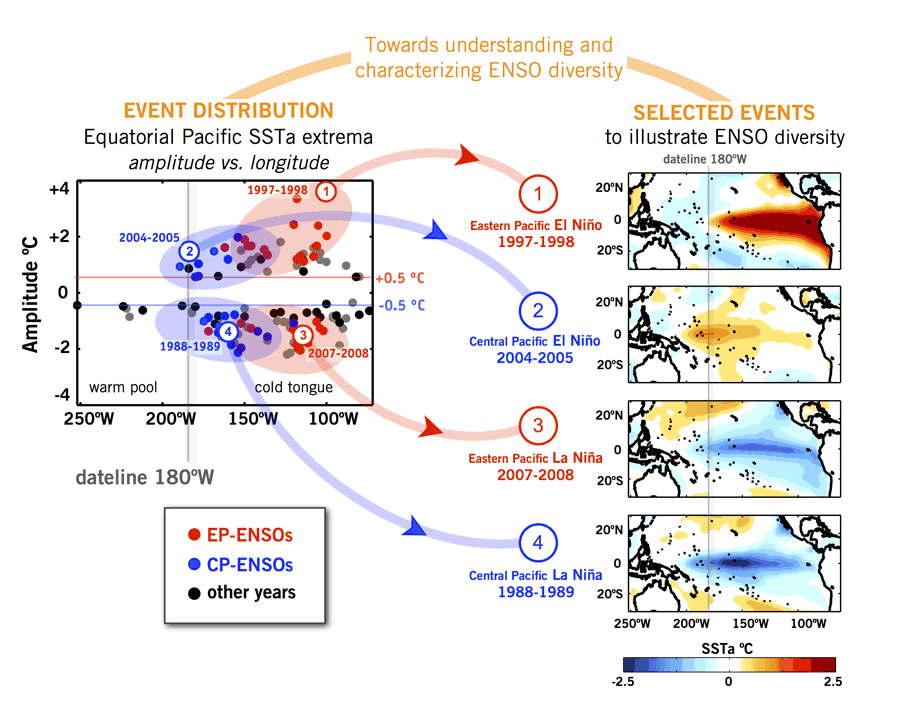
The El Niño / Southern Oscillation (ENSO) is Earth’s strongest interannual climate fluctuation, impacting weather, ecosystems, and economies around the world. Understanding the range of ENSO variation could help lead to longer range predictions of El Niño and La Niña events. The authors review the current state of understanding of diversity among different El Niño / Southern Oscillation (ENSO) events, which differ from event to event in their amplitude, spatial pattern, temporal evolution, dynamical mechanisms, and impacts.
ENSO diversity is apparent in historical climate records, paleo proxy records, and model simulations. As yet there is no clear evidence for distinct “types” of ENSO events, but rather a continuum of variability with striking extremes. ENSO warm events (El Niños) are generally more diverse than cold events (La Niñas). Compared to weaker El Niños, stronger El Niños tend to exhibit their peak warm sea surface temperature (SST) anomalies farther east, with a relatively greater role in the ocean mixed layer heat budget for thermocline motions, as opposed to oceanic zonal advection and air-sea heat fluxes. El Niño events of all types are often preceded (and in part triggered) by westerly wind events in the western and central equatorial Pacific, which, in turn, are favored by relaxation of the equatorial zonal SST gradient, recharge of the equatorial ocean heat content, and equatorward propagation of off-equatorial disturbances via wind-evaporation-SST feedbacks.
Present-day prediction systems can skillfully distinguish the flavor of ENSO evolution up to six months in advance. On longer time scales, simulations suggest that multi-decadal prevalence of a given ENSO flavor can occur at random, even in the absence of external changes in radiative forcings. Anthropogenic forcings are expected to increase the intensity of ENSO rainfall anomalies in the central equatorial Pacific.
Future work will focus on understanding how ENSO diversity relates to decadal- and longer-term variations in the background climate state, and on clarifying the sources and limits of predictability for different ENSO events. Additional goals include improving the representation of ENSO diversity in climate models and in observational and paleo reconstructions, and improving operational forecasts of ENSO.


