

A Topographic Drag Scheme for Climate Models
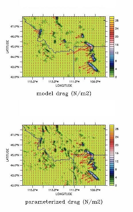
Mountain drag closure schemes are used when the features that cause most of the drag in the real atmosphere are too small to be resolved. This is typically the case for climate models. Models at GFDL are now testing a scheme that replaces ad-hoc and statistical characterizations of the topography with an analytical formula that is exact for a given topography when the flow is linear, hydrostatic and non-rotating (Garner 2005). One way to see if the scheme is working is to run a model for a short time at extremely high resolution and compare the resolved drag to what the scheme provides when the flow is coarse-grained to climate-model resolution.
The figure shows such a comparison obtained over a portion of the central Rockies (Wyoming, Montana and Idaho). This is based on a regional simulation driven at the lateral boundaries by reanalyzed fields from January 2003. The upper panel depicts the one-week average total drag (the so-called base flux) resolved by the model running at 6-km horizontal resolution. The lower panel is the closure, or parameterization, obtained by smoothing the flow to about 1-deg horizontal resolution. The input topography used by the parameterization is even better resolved than in the simulation. The color contours show the magnitude of the drag in N/m2 , while the arrows show its magnitude and orientation. In the case of the vectors, only 1 out of 3 grid points is plotted in each direction. The agreement between the magnitudes has been improved substantially by incorporating a dimensional analysis of the drag in areas that are likely blocked or deflected.