

Wave Atmosphere Coupled System
As global atmospheric climate models move to higher horizontal resolution (25 – 50 km), it is demonstrated as a useful tool to study the impact of global warming on tropical cyclone statistics; the causes of year-to-year variability in global tropical cyclone activity; and the relationship between tropical cyclone frequency/intensity and climate change. (Read more…)
However, the current global models still have difficulties in simulating the intensity of the storms (Zhao et al 2009). Besides the relatively coarse resolution in the climate models compare to the regional models, the bulk formula drag parameterization could also be one of the reasons. The air-sea momentum flux is usually represented by the drag coefficient, Cd, or the sea surface roughness, zo. Field observations have shown large scattering in Cd especially under high wind condition (Figure 1). It is argued that this large scattering is caused by the spatial and time variation in the wave field. In order to create more realistic sea surface roughness for the atmospheric model, we are working on coupling WaveWatch III, the operational wave model developed at NCEP/EMC, to the GFDL global climate model. The wave-atmosphere coupling interface codes have been implemented within the GFDL FMS framework and tested in the GFDL low-resolution global forecast system (based on the finite-volume model on the cubed-sphere). The coupled system runs successfully at low resolution. The model test for higher resolution is on going. After the success of high-resolution tests, we will evaluate the impacts of direct wave model coupling on hurricane intensity and track forecasts through both short-term forecast runs (7 days) and long term runs (seasonal forecasts).
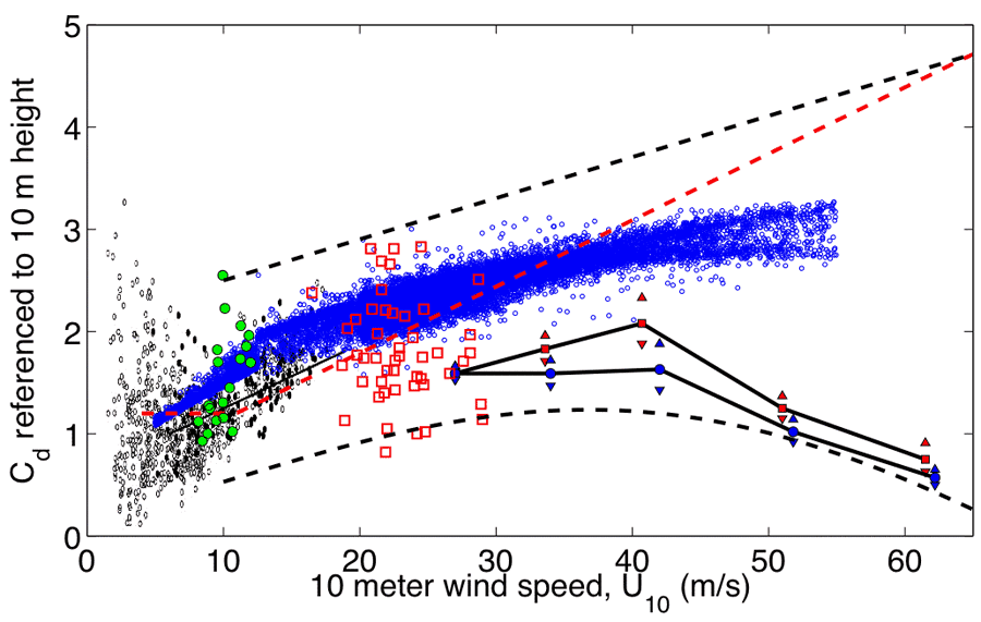
Figure 1. Drag coefficient (Cd) comparison from different studies. The black circles and dots in the back ground are field measurements presented in Figure 4 in Drennan et al (2003). The green circles are field measurements from Drennan et al (1996). The red open squares are CBLAST field measurements from French et al (2007). The red dashed line is Large and Pond (1981) wind speed dependent formula. The black line with red squares (blue dots) shows the drag coefficient estimated by Powell (2007) based on the 20 – 160 m (10 – 160 m) surface layers, the upward and downward pointing red (blue) triangles indicate the 95% confidence limits on the estimates. The blue circles are Cd produced by the wave-atmosphere coupled system.
Reference
- Zhao, M., I. Held, S. J. Lin, and G. Vecchi 2009: Simulations of global hurricane climatology, interannual variability, and response to global warming using a 50-km resolution GCM. J. Clim., 22, 6653-6678.
- Drennan, W. M., M. A. Donelan, E. A. Terray, and K. B. Katsaros, 1996: Oceanic turbulence dissipation measurements in SWADE. J. Phys. Oceanogr., 26, 808-815.
- Drennan, W. M., G. C. Graber, D. Hauser, and C. Quentin, 2003: On the wave age dependence of wind stress over pure wind seas. J. Geophys. Res, 108, 8062, doi:10.1029/2000JC000715.
- French, J. R., W. M. Drennan, and J. A. Zhang, 2007: Turbulent Fluxes in the Hurricane Boundary Layer, Part I: Momentum Flux. J. Atmos. Sci., 64, 1089-1102
- Holland, G. J., 1980: An analytic model of the wind and pressure profiles in hurricanes. Mon. Wea. Rev., 108, 1212-1218.
- Powell, M. D., 2007: Drag coefficient distribution and wind speed dependence in tropical cyclones. Final report to the national oceanic & atmospheric administration (NOAA) joint hurricane testbed (JHT) program.