August 17th, 2012
Key Findings
- For the first time, the contribution of anthropogenic dust has been determined from satellite measurements.
- Globally, anthropogenic emission contributes to 25% of all dust emissions..
- There is significant disparity of anthropogenic dust emission between regions, with the largest contribution from Australia (75%) and the lowest from North Africa (6%).
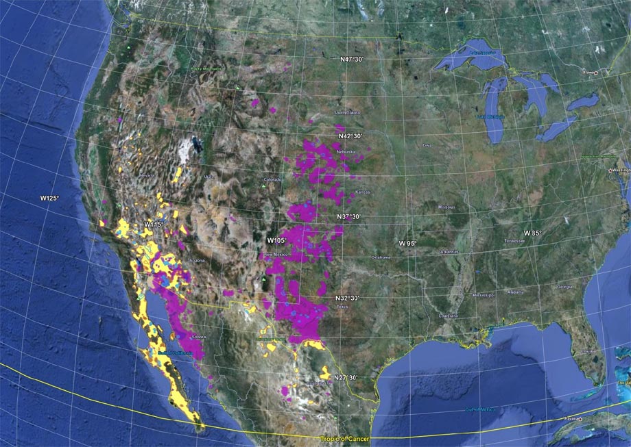
- In some areas, dust sources appear to have changed over the past two decades, when compared to older satellite products — particularly in the United States.
P. Ginoux, J. M. Prospero, T. E. Gill, N. C. Hsu, and M. Zhao. Journal: Review of Geophysics. DOI: 10.1029/2012RG000388
Summary
Dust is one of the most abundant aerosols in the atmosphere, and by scattering and absorbing solar radiation, it affects climate. In particular, anthropogenic dust is a significant source of radiative forcing on the climate system. Increasing numerical resolution of climate models provides an opportunity to create a realistic, high-resolution dust-source inventory.
The goal of this study was to detect and quantify anthropogenic dust from satellite measurements. The coauthors sought to produce a high-resolution inventory of dust sources for varied applications, such as: aerosol modeling, forecasting, transportation, air quality research and management, wind erosion management, etc.
Anthropogenic dust sources are generally related to ephemeral lakes or rivers. This implies that they are sensitive to the hydrological cycle and consequently climate change. Conversely, natural sources are loosely related to ephemeral water bodies, as they correspond to paleolakes with a deep layer of alluvium.
Dust forecasting is particularly important in the Southwest U.S., and other regions of the world where there are intense dust events. Realistic high resolution dust sources are instrumental to increase the skill of such forecasting.
Using a unique method, the authors were able to detect dust sources where other methods could not, including highly populated areas such as in the Sahel or the Ganges Basin where dust is especially difficult to detect.
Dust sources are found to be associated with land use, and subject to wind erosion. Wind erosion of farmland is of concern for the sustainability of agriculture, and through erosion of natural sources, dust particles affect air quality, air visibility, and climate. Using GFDL’s high resolution atmospheric model, it was found that dust emission from agriculture accounts for 25% globally, with strong disparity between regions. In addition, the authors show that agricultural dust is often associated with ephemeral water-bodies, such as rivers or lakes, and are therefore particularly sensitive to climate variability.
Known weaknesses
Satellite estimates of aerosol optical depth are overestimated in some areas. Also, the emissions are highly sensitive to the threshold of wind erosion which is poorly constrained in our study. Using a dependency of this threshold on vegetation measured from satellite data would provide a more robust estimate of emissions and therefore contribution of each source types (natural, anthropogenic, and hydrologic).