August 4th, 2023
Key Findings
- This study investigated unexpected issues that arise in tropical cyclone prediction as models move to higher resolution and become increasingly capable of explicitly resolving convection
- Better regulation of explicit convection reduces North Atlantic hurricane track errors in a high-resolution model by 10% at days 4 and 5
- Improved track forecasts are related to a more realistic representation of the North Atlantic subtropical ridge
- Explicit convection is modulated by implicit diffusivity in the model’s advection scheme
Kun Gao, Lucas Harris, Morris Bender, Jan-Huey Chen, Linjiong Zhou, Thomas Knutson. Geophysical Research Letters. DOI: 10.1029/2023GL103329
Hurricanes, also known as tropical cyclones (TC), are the costliest weather disasters in the U.S. and accurate hurricane track and intensity forecasts are crucial for early preparation. High-resolution models (approximately 3 km grid spacing or finer) covering a large domain are emerging as powerful tools for hurricane prediction. However, while the use of high resolution helps improve hurricane intensity prediction, it can also make the model more prone to develop errors in the prediction of steering flow and hurricane tracks – due to the possible impact of prevalent small-scale features resolved by the model. This study suggests that regulating small-scale convection activity in a high-resolution model can significantly improve hurricane track predictions at days 4 and 5.
Currently, dynamical TC track and intensity predictions are generated by two types of models – global models with relatively coarse resolution (10 km) and regional models with relatively high resolution (1 km). Newly emerging cloud-resolving models with a large domain have either minimized or eliminated the impact of externally imposed boundary conditions, and therefore have the potential to improve both track and intensity prediction skills for operational forecasting. However, major efforts are still needed to achieve this ambitious goal. In particular, a comprehensive understanding of the error sources for the prediction of large-scale environments is needed.
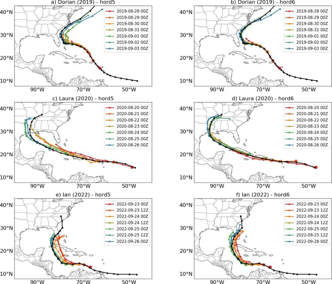
Are there unexpected issues that arise in TC prediction as we move to higher resolution (approaching 3 km) and models become increasingly capable of explicitly resolving convection? The authors found that at such high resolutions, the resolved convection can become overly active, which degrades the large-scale circulation, leading to large track error in many cases. Better regulation of the marginally resolved convection by optimizing the model’s advection scheme alleviates this issue and improves the track prediction skill by 10% at days 4 and 5. This study underscores the role of grid-scale convection in high resolution hurricane models, and the often overlooked role it plays in hurricane track forecasting skill.
The authors used T-SHiELD, a two-way nested “Tropical” configuration of the GFDL’s System for High-resolution prediction on Earth-to-Local Domains model (SHiELD). T-SHiELD features a large high-resolution nest (3.25 km grid spacing) over the North Atlantic embedded in the global (13 km grid spacing) domain. T-SHiELD uses the nonhydrostatic Finite-Volume Cubed-Sphere (FV3) dynamical core and a suite of physical parameterizations that either originated from NOAA’s Global Forecast System or were developed at GFDL.
In controlled experiments, only the choice of the horizontal advection scheme was changed in the nested domain of T-SHiELD. Two sets of retrospective 5-day forecasts are conducted for five hurricane seasons (2018 to 2022), using one of two different horizontal advection schemes in the nested region.
Forecasts from two operational models, the Global Forecast System and Hurricane Weather Research and Forecasting model, served as benchmarks, to show that both configurations of T-SHiELD have reasonable track prediction performance. One of the two T-SHiELD configurations actually showed improved track performance compared to the GFS and HWRF models beyond 72 hr, although it was not a main goal of this study.
These experiments revealed a clear connection between the choice of the horizontal advection scheme and TC track prediction errors in simulations where deep convection is explicitly resolved. Controlling the prevalence of small-scale unorganized convection in a high-resolution model is important for maintaining the strength and western extent of the North Atlantic subtropical ridge, which is critical for the track prediction of many Atlantic TCs, especially for those threatening landfall on the continental US.
This research carries several practical implications. It shows that explicit convection can have significant impacts on the large-scale steering flow and storm track predictions, including unexpected ways that do not occur in lower-resolution models. It also suggests that tracks can be improved by optimizing dynamical parameters controlling explicit convection in these models. This is especially important since NOAA’s newly launched operational Hurricane Analysis and Forecasting System shares the same FV3 dynamical core as T-SHiELD. The authors encourage the community to pay better attention to the behavior of the explicit convection and its aggregate large-scale impact during the development of high-resolution hurricane forecasting models, and more broadly global storm-resolving weather and climate models.