

Simulating the Breakup of Giant Tabular Iceberg A68a
Contacts for information:
 Alex Huth |
 Olga Sergienko (Princeton) |
 Alistair Adcroft (Princeton) |
Related Areas of Research:
Modeling Tabular Icebergs
Ocean and Ice Processes
Ice-Ocean Interactions
Ice Sheet Dynamics
Iceberg A68a
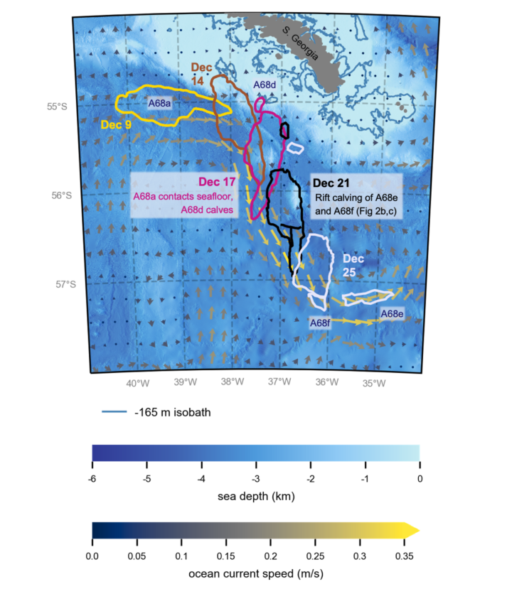
Giant tabular iceberg A68 was the sixth largest iceberg on record, with an initial surface area of 5800 km2 that exceeded the area of Delaware. It calved from the Larsen C Ice Shelf on the Antarctic Peninsula in July, 2017, and split into two bergs a few days later: the 5710 km2 A68a and 90 km2 A68b. The drift and decay of A68a was followed closely by researchers and media outlets. By November, 2020, it had drifted north to within a few hundred kilometers of South Georgia Island. While it initially appeared that the iceberg could anchor in shallow water, cutting off penguins and seals from their feeding grounds, the iceberg instead rotated towards deeper water in mid-December. As shown in Figure 1, A68a briefly contacted the seafloor during this rotation around December 17th, which caused a smaller “child” iceberg to break from its tip. Also shown is a second breakup event, which occurred a few days later when unknown forces caused A68a to fragment into several pieces in the deep, open ocean.
iKID simulation
We simulated the December, 2020 evolution of A68a with our new bonded-particle iceberg modeling framework, the “improved” Kinematic Iceberg Dynamics (iKID) module (Huth et al., 2022). The iKID module allows representation of giant icebergs and their breakup within climate models. Our goal was to demonstrate that iKID could capture the observed drift and both breakup events of A68a, and to determine the mechanism that caused the second breakup event. The simulation (below) captures the first breakup caused by contact with the seafloor around December 17th, where the modeled grounding zone is represented by the orange box. The second breakup event, around Dec 20th, is also captured. We determined that it was triggered by a new breakup mechanism not previously considered: “ocean-current shear”, where part of the iceberg became positioned within stronger ocean currents (arrows) than the rest of the iceberg, causing enough tension along the iceberg body to break it into pieces. Identifying this new breakup mechanism and developing the methods to simulate it will improve the fidelity of climate simulations. Iceberg breakup influences the location and rate at which icebergs deposit freshwater into the ocean as they melt, which can substantially impact ocean circulation, sea-ice formation, and the marine biosphere.
iKID simulation of the drift and two breakup events of iceberg A68a in December, 2020. The first breakup was caused by contact with the seafloor while the second breakup was caused by strong ocean-current shear.
References
Earth and Space Research (ESR), 2009: OSCAR third deg. Ver. 1. PO.DAAC, CA, USA. Dataset accessed at https://doi.org/10.5067/OSCAR-03D01.
GEBCO Bathymetric Compilation Group, 2021: The GEBCO_2021 Grid – a continuous terrain model of the global oceans and land. NERC EDS British Oceanographic Data Centre NOC. Dataset accessed at https://doi.org/10.5285/c6612cbe-50b3-0cff-e053-6c86abc09f8f.
Hogg, O. T., V. A. I. Huvenne, H. J. Griffiths, B. Dorschel, and K. Linse, 2016: Landscape mapping at sub-Antarctic South Georgia provides a protocol for underpinning large-scale marine protected areas, Scientific Reports, 6(1), 33163, doi:10.1038/srep33163.
Huth, A., A. Adcroft, O. Sergienko, and N. Khan, 2022: Ocean currents break up a tabular iceberg. Science Advances, 8(42), eabq6974. doi:10.1126/sciadv.abq6974.