June 10th, 2025
Key Findings
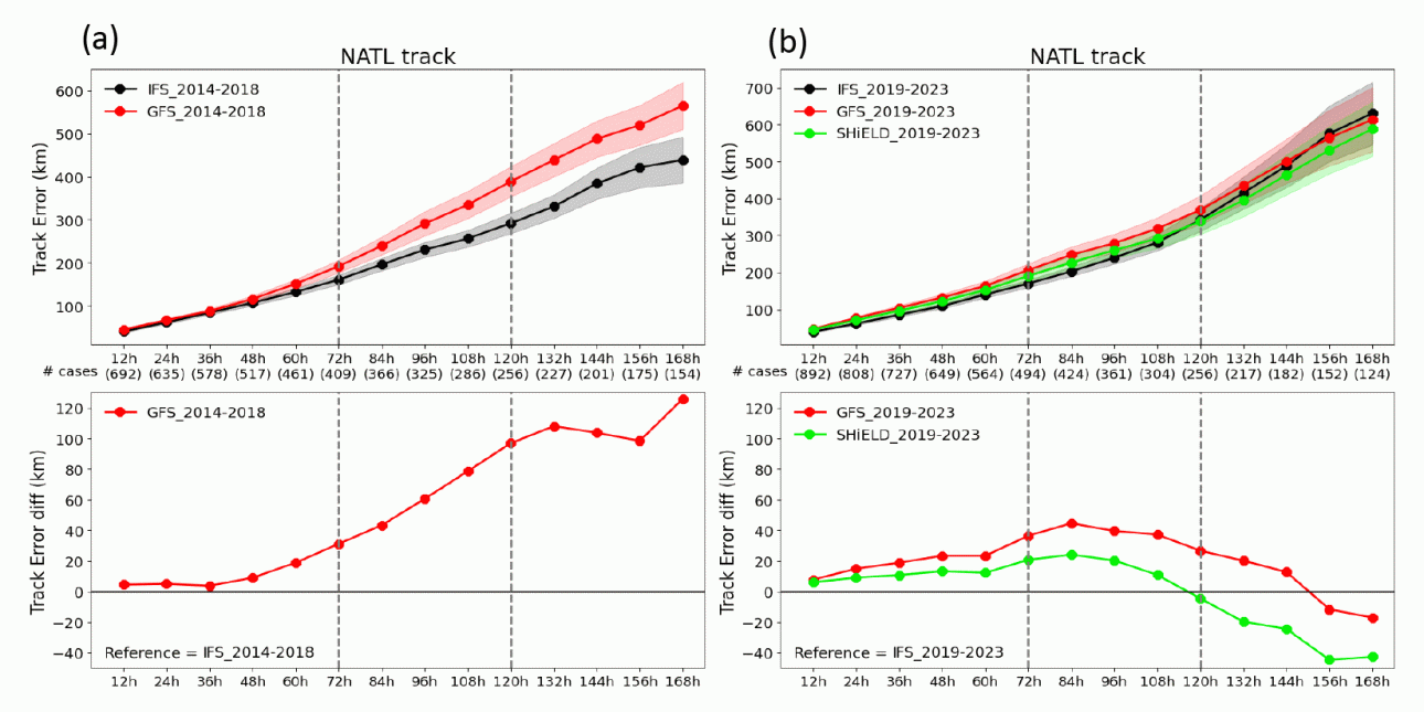
- The gap in hurricane track forecast skill between the American FV3-based models and the world-leading European Centre model has substantially decreased since the major upgrade of the U.S. models’ dynamical core.
- The 10-year progression of the various American and the European models’ North Atlantic hurricane forecast skills are presented to demonstrate this achievement.
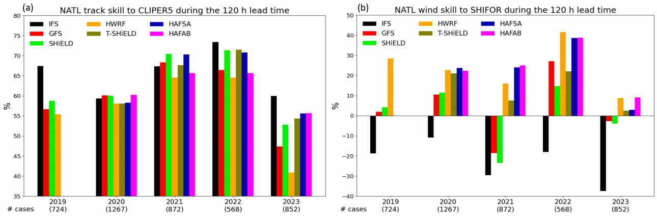
- NOAA’s newly operational HAFS models and the experimental T-SHiELD showed outstanding performance in both track and intensity forecasts.
Jan-Huey Chen, Timothy Marchok, Morris Bender, Kun Gao, Sundararaman Gopalakrishnan, Lucas Harris, Andrew Hazelton, Bin Liu, Avichal Mehra, Matthew Morin, Fanglin Yang, Xuejin Zhang, Zhan Zhang, Linjiong Zhou. Bulletin of the American Meteorological Society. DOI: 10.1175/BAMS-D-24-0036.1
Hurricanes are one of the most destructive natural events on Earth. Improving the skill of hurricane forecasts, especially for those in the North Atlantic basin, has always been an important objective for government weather forecast agencies, emergency managers, and the atmospheric science research community in the United States. The model developed by the European Centre for Medium-range Weather Forecasts (ECMWF) has been recognized as providing the most skillful guidance for track forecasts for years. However, the performance of American models for hurricane forecasting has been catching up.
This research paper presents the 10-year progression of the North Atlantic hurricane forecasts in the various American Finite-Volume Cubed-Sphere Dynamical Core (FV3)-based models, including the operational Global Forecast System (GFS), the operational Hurricane Analysis and Forecast System (HAFS), and GFDL’s experimental SHiELD.
From 2019 to 2023 the gap in hurricane forecast track skill between American models and the ECMWF’s Integrated Forecasting System (IFS) was substantially decreased, coinciding with the major upgrade of the U.S. models’ dynamical core. In addition, the FV3-based global Global Forecast System (GFS) and the research-oriented System for High-resolution prediction on Earth-to-Local Domains (SHiELD) showed much improved hurricane intensity forecast skill, compared to IFS and the previous generation of American global models – marking a significant achievement of U.S. global model development.
The next-generation FV3-based regional hurricane models showed outstanding performance in both hurricane track and intensity forecasts. The newly operational HAFS-A and HAFS-B successfully reproduced the intensity forecast skill achieved by NOAA’s previous generation operational Hurricane Weather Research Forecast Model. Furthermore, both HAFS models and the experimental global-nested T-SHiELD showed comparable or even better hurricane track forecasts than the global models from 2020 to 2023, marking the first time any hurricane model has had good skill for both intensity and track. This represents a considerable success for NOAA in upgrading the agency’s regional hurricane models.
The improved hurricane track and intensity forecasts described by the authors can be taken as an indicator of the progress made by the entire Unified Forecast System community, reflecting major upgrades of the dynamical core, physics and data assimilation in the operational GFS and HAFS. To further improve the American models’ hurricane prediction, many aspects are worth exploring and approaching, including data-driven machine-learning weather models. Properly adopting the new technologies to best complement the physical models could maximize the benefits from both, and possibly produce the next great advance in hurricane prediction.
This work was funded by the NOAA Research Global-Nest Initiative.