


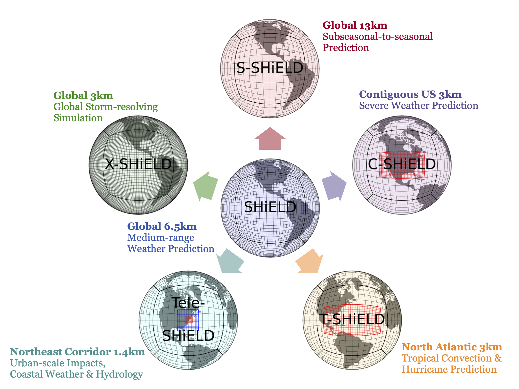
SHiELD is a Unified Forecast System (UFS) prototype atmosphere model showing the power of a unified prediction system across a variety of time and space scales designed for a wide array of applications. It shows the abilities of the Finite-Volume Cubed-Sphere Dynamical Core (FV3), especially its flexible nonhydrostatic dynamics, variable-resolution capabilities, and integrated physics, coupled with the elegance of the Flexible Modeling System (FMS) framework. Improvements in FV3 or the physics in SHiELD can be easily transferred into other FV3-based models, including the GFDL Modeling Suite and the Unified Forecast System.
SHiELD is an open-source model with code and drivers available on GitHub. A container, SHiELD-in-a-Box, is also available for convenient portable usage of SHiELD.
| Configuration | Use | Domain | Integration Length |
|---|---|---|---|
| SHiELD | Medium-range weather prediction | Global 6.5-km with 91 vertical levels | 240 hours (10 days) |
| C-SHiELD | Short-to-medium-range contiguous US severe weather prediction | Global 13-km, 3-km CONUS nest, 63 vertical levels | 126 hours (5.25 days) |
| T-SHiELD | Medium-range Atlantic tropical cyclone and hurricane prediction | Global 13-km, 3.5-km tropical Atlantic nest, 63 vertical levels | 168 hours (7 days), hurricane season only |
| S-SHiELD | Subseasonal-to-seasonal prediction | Global 13-km with 91 vertical levels | 30 to 90 days, with up to 10 ensemble members |
| X-SHiELD | eXperimental DYAMOND-class global storm-resolving model (GSRM) | Global 3.25-km with 79 vertical levels | 40 days |
| R-SHiELD | Regional limited-area model (LAM) configuration | Regional 13, 3, or 1 km | 54 hours |
| Tele-SHiELD | Short-to-medium-range severe weather prediction, urban-scale impacts, coastal weather and hydrology, sub-grid scale land-use variability | Global 13-km, 4.3-km first nest, 1.4-km second nest for Northeast Corridor areas, 91 vertical levels | 240 hours (10 days) |
In-Depth Information for Near Real-Time Configurations
2024 SHiELD Global Prediction System
The 6.5-km SHiELD is a global medium-range prediction model that serves as the “core” for SHiELD development and the foundation for other configurations. This model represents a major step forward with enhanced FV3 algorithms, improved model initialization, and a holistically-developed, scale-aware suite of physical parameterizations optimized for the convective “gray zone” of resolutions below 10 km. It is designed to bridge the gap between traditional medium-range forecasting and global storm-resolving simulations while remaining computationally efficient for real-time forecasting. The 6.5-km SHiELD also retains the flexibility to run with FV3’s stretched and nested grids, enabling high-resolution focus on specific regions of interest.
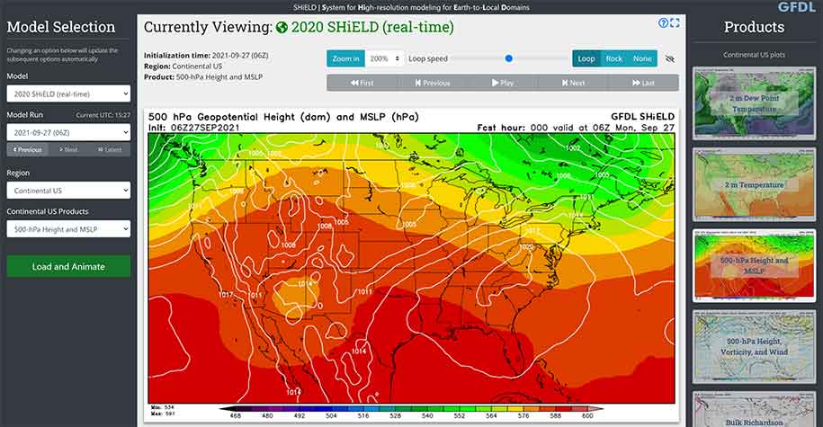
SHiELD 2024 real-time: https://shield.gfdl.noaa.gov/?model=SHiELD_2024
Updated: December, 2024
Lead: Linjiong Zhou
Operator: Matt Morin
Contributors: Lucas Harris, Kun Gao, Kai-Yuan Cheng, and the GFDL FV3 Team
Forecast Experiment Design:
- Initialized 00Z, 06Z, 12Z, and 18Z daily from operational GFS analyses
- Integrated to 10 days
- Horizontal Resolution: 6.5-km global domain (C1536)
- Vertical Resolution: 91 layers, lowest mid-level at ~12 m, model top at 40 Pa
- Computational Performance: 120 min/10 days using 12,288 cores on Gaea C5
Dynamical Core:
- Nonhydrostatic FV3 Lagrangian dynamics
- GFDL cloud microphysics v3
Physics Package:
- Scale-aware TKE-EDMF planetary boundary layer scheme
- Scale-aware SAS (shallow and deep) convection scheme
- RRTM radiation with GFDL cloud-radiation interaction scheme
- GFS (orographic and convective) gravity wave drag scheme
Ocean Component:
- 1-D mixed-layer ocean model
Land Component:
- Noah land surface model
References:
- Zhou, Linjiong, Lucas Harris, Jan-Huey Chen, Kun Gao, Cheng, Kai-Yuan, Mingjing Tong, Kaltenbaugh, Alex, Matthew J Morin, Joseph Mouallem, Lauren Chilutti, and Lily Johnston, December 2024: Bridging the Gap Between Global Weather Prediction and Global Storm-Resolving Simulation: Introducing the GFDL 6.5-km SHiELD. Journal of Advances in Modeling Earth Systems, 16, doi:10.1029/2024MS004430.
- Zhou, Linjiong, Lucas Harris, Jan-Huey Chen, Kun Gao, Huan Guo, Baoqiang Xiang, Mingjing Tong, J Jacob Huff, and Matthew J Morin, July 2022: Improving global weather prediction in GFDL SHiELD through an upgraded GFDL cloud microphysics scheme. Journal of Advances in Modeling Earth Systems, 14(7), doi:10.1029/2021MS002971.
- Harris, Lucas, Linjiong Zhou, Shian-Jiann Lin, Jan-Huey Chen, Xi Chen, Kun Gao, Matthew J Morin, Shannon L Rees, Yongqiang Sun, Mingjing Tong, Baoqiang Xiang, Morris A Bender, Rusty Benson, Kai-Yuan Cheng, Spencer K Clark, Oliver Elbert, Andrew T Hazelton, J Jacob Huff, Alex Kaltenbaugh, Zhi Liang, Timothy Marchok, Hyeyum Hailey Shin, and William F Stern, October 2020: GFDL SHiELD: A Unified System for Weather-to-Seasonal Prediction. Journal of Advances in Modeling Earth Systems, 12(10), doi:10.1029/2020MS002223.
- Magnusson, L, Jan-Huey Chen, Shian-Jiann Lin, Linjiong Zhou, and Xi Chen, July 2019: Dependence on initial conditions vs. model formulations for medium‐range forecast error variations. Quarterly Journal of the Royal Meteorological Society, 145(722), doi:10.1002/qj.3545.
- Chen, Jan-Huey, Shian-Jiann Lin, L Magnusson, Morris A Bender, Xi Chen, Linjiong Zhou, Baoqiang Xiang, Shannon L Rees, Matthew J Morin, and Lucas Harris, April 2019: Advancements in Hurricane Prediction with NOAA’s Next Generation Forecast System. Geophysical Research Letters, 46(8), doi:10.1029/2019GL082410.
- Chen, Jan-Huey, Shian-Jiann Lin, Linjiong Zhou, Xi Chen, Shannon L Rees, Morris A Bender, and Matthew J Morin, September 2019: Evaluation of Tropical Cyclone Forecasts in the Next Generation Global Prediction System. Monthly Weather Review, 147(9), doi:10.1175/MWR-D-18-0227.1.
- Zhou, Linjiong, Shian-Jiann Lin, Jan-Huey Chen, Lucas Harris, Xi Chen, and Shannon L Rees, July 2019: Toward Convective-Scale Prediction within the Next Generation Global Prediction System. Bulletin of the American Meteorological Society, 100(7), doi:10.1175/BAMS-D-17-0246.1.
2023 C-SHiELD Global-to-Regional CONUS Prediction System
C-SHiELD is our Contiguous United States nested model used for prediction of high-impact weather events, especially severe thunderstorms and heavy precipitation. This model is capable of simulating individual convective storms without a parameterization, thereby giving better information on the impacts of these events. The global-nested configuration of C-SHiELD allows it to make useful predictions much farther in advance than do limited-area prediction models typically used for convective-scale prediction, allowing for unique medium-range prediction of these events. C-SHiELD is contributed in real-time to the Hazardous Weather Testbed’s Spring Forecasting Experiment every May. We also use a lower-resolution version of C-SHiELD to explore subseasonal prediction of severe thunderstorm outbreaks.
C-SHiELD 2023 real-time: https://shield.gfdl.noaa.gov/?model=C-SHiELD_2023
Updated: May 30, 2023
Lead: Kai-Yuan Cheng
Operator: Matt Morin
Contributors: Linjiong Zhou, Lucas Harris, and the GFDL FV3 Team
Forecast Experiment Design:
- Initialized 00Z and 12Z daily from operational GFS analyses
- Integrated to 5.25 days
- Horizontal Resolution: 13-km global domain (C768), 3-km CONUS nested domain (2160 x 1200 grid cells)
- Vertical Resolution: 63 layers, lowest mid-level at ~15 m, model top at 64 Pa
- Computational Performance: 118 min/5.25 days using 3024 cores on Gaea C5
FV3 Dynamical Core:
- Positive-definite tracer advection
- Virtually-inviscid advection scheme (hord=5)
- Two-way grid nesting with simplified two-way update
- GFDL Inline Cloud Microphysics version 3 with hail on nest
- Saturation Adjustment Delay (saturation adjustment is done only at the final remapping timestep)
SHiELD (GFS) Physics Package:
- NCEP 2017 Scale-Aware SAS (shallow and deep) convection tuning to improve convection structure and propagation
- TKE-EDMF Planetary Boundary Layer with GFDL 2021 updates
- RRTM Radiation with bugfix and 2021 GFDL cloud-radiation interaction
- GFS (orographic and convective) Gravity Wave Drag with GFDL 2018 updates
SHiELD Ocean Component:
- 2019 Mixed-layer Ocean Model
SHiELD (GFS) Land Component:
- Noah Land Surface Model with GFDL 2020 updates on global domain and Noah-Multiparameterization Land Surface Model with GFDL 2021 updates on nest domain
References:
- Kaltenbaugh, Alex, Harris, Lucas, Cheng, Kai-Yuan, Linjiong Zhou, Matthew J Morin, and William F Stern, August 2022: Using GFDL C-SHiELD for the prediction of convective storms during the 2021 spring and summer. NOAA technical memorandum OAR GFDL, 2022-001, doi:10.25923/ednx-rm34.
- Potvin, C K., J R Carley, A Clark, L J Wicker, P S Skinner, A E Reinhart, B T Gallo, J S Kain, G Romine, E Aligo, K Brewster, D C Dowell, and Lucas Harris, et al., October 2019: Systematic comparison of convection-allowing models during the 2017 NOAA HWT Spring Forecasting Experiment. Weather and Forecasting, 34(5), doi:10.1175/WAF-D-19-0056.1.
- Harris, Lucas, Shannon L Rees, Matthew J Morin, Linjiong Zhou, and William F Stern, June 2019: Explicit prediction of continental convection in a skillful variable‐resolution global model. Journal of Advances in Modeling Earth Systems, 11(6), doi:10.1029/2018MS001542.
- Zhang, C, M Xue, T A Supinie, F Kong, N Snook, K W Thomas, K Brewster, Y Jung, Lucas Harris, and Shian-Jiann Lin, March 2019: How Well Does an FV3-based Model Predict Precipitation at a Convection-Allowing Resolution? Results from CAPS Forecasts for the 2018 NOAA Hazardous Weather Testbed with Different Physics Combinations. Geophysical Research Letters, 46(6), doi:10.1029/2018GL081702.
2024 T-SHiELD Global-to-Regional Tropical Nested Prediction System
T-SHiELD is a nested model for Tropical prediction, especially tropical cyclones. Unique among tropical cyclone models, T-SHiELD uses a 3.25 km nest over the entire tropical North Atlantic. This large convective-scale domain allows us to explore the effects of explicitly-simulated convection on tropical cyclogenesis and synoptic-scale systems, which in turn has a significant impact on tropical cyclone development and track. It can also be configured to run over other ocean basins, and is also useful for predicting strong extratropical storms in the North Atlantic in which intense winds and precipitation may occur over small-scale areas. T-SHiELD is contributed in real-time every year in late summer/early fall to the HFIP Real-time Experiment (HREx).
T-SHiELD 2024 real-time: https://shield.gfdl.noaa.gov/?model=T-SHiELD_2024
Updated: July 26, 2024
Lead: Kun Gao
Operator: Matt Morin
Contributors: GFDL FV3 Team
Forecast Experiment Design:
- Initialized every six hours (00, 06, 12, and 18Z) from operational GFS analyses
- TC vortex initialization procedure applied for strong storms (Vmax > 30m/s)
- Integrated to 6 days
- Horizontal Resolution: 13 km uniform global domain (C768r10), 3.25 km North Atlantic nested domain (2304 x 1152 grid cells)
- Vertical Resolution: Coarse grid 63 layers, lowest mid-level at ~15 m, model top at 64 Pa; Vertically-nested grid 75 layers, lowest mid-level at ~10 m, model top at 200 Pa
- Computational Performance: 250 min/6 days using 3072 cores on Gaea C5
FV3 Dynamical Core:
- L75 vertical level configuration with enhanced near-surface resolution
- Hord 6 for horizontal advection of dynamical quantities
- Hord -5 (positive-definite) for tracers
SHiELD (GFS) Physics Package:
- TKE-EDMF PBL with shear-dependent vertical diffusion
- Refined mixing length parameterization in the nested region
- Refined surface enthalpy flux parameterization in the nested region
- No deep convection parameterization in the nested region
SHiELD Ocean Component:
- Mixed-layer Ocean Model
- Improved thermal roughness length parameterization under high winds
SHiELD (GFS) Land Component:
- High-resolution Noah Land Model with GFDL updates
References:
- Gao, Kun, Lucas Harris, Morris A Bender, Jan-Huey Chen, Linjiong Zhou, and Tom Knutson, 2023: Regulating fine-scale resolved convection in high-resolution models for better hurricane track prediction . Geophysical Research Letters, , DOI:10.1029/2023GL104587
- Gao, Kun, Lucas Harris, Linjiong Zhou, Morris A Bender, and Matthew J Morin, 2021: On the sensitivity of hurricane intensity and structure to horizontal tracer advection schemes in FV3. Journal of the Atmospheric Sciences, 78(9), DOI:10.1175/JAS-D-20-0331.1
References for Experimental Configurations
2024 S-SHiELD Subseasonal-to-Seasonal Prediction System
S-SHiELD is a lower-resolution configuration of SHiELD intended for Subseasonal-to-Seasonal (S2S) simulation, intended for extended-range prediction with a focus on extreme weather events. S-SHiELD is currently under development. We are also working closely with the developers of SPEAR on S2S product development.
References:
- Xiang, Baoqiang, Lucas Harris, Thomas L Delworth, Bin Wang, Guosen Chen, Jan-Huey Chen, Spencer K Clark, William F Cooke, Kun Gao, J Jacob Huff, Liwei Jia, Nathaniel C Johnson, Sarah B Kapnick, Feiyu Lu, Colleen McHugh, Yongqiang Sun, Mingjing Tong, Xiaosong Yang, Fanrong Zeng, Ming Zhao, Linjiong Zhou, and Xiaqiong Zhou, in press: S2S prediction in GFDL SPEAR: MJO diversity and teleconnections. Bulletin of the American Meteorological Society. DOI:10.1175/BAMS-D-21-0124.1. September 2021.
2021 GFDL X-SHiELD eXperimental GSRM
X-SHiELD is an eXperimental Global Storm Resolving Model (GSRM) or kilometer-scale (K-scale) model run at a sufficiently high global resolution to explicitly simulate individual convection cells. X-SHiELD is GFDL’s contribution to the DYAMOND project, an international intercomparison of GSRMs. We are also collaborating with AI2 Climate Modeling to accelerate X-SHiELD using emerging computing platforms, and to train a Machine Learning system on the output to create an efficient emulator of the expensive GSRM.
Animations of a previous version of X-SHiELD can be seen on the Mesoscale Dynamics Data Visualizations page.
Lead: Lucas Harris
Contributors: Linjiong Zhou, Kai-Yuan Cheng, Kun Gao, and the GFDL FV3 Team
Special thanks to Daniel Klocke (MPI)
Our submission of X-SHiELD output to DYAMOND is available at ftp://data1.gfdl.noaa.gov/4/SHiELD/202011/20200120.00Z.C3072.L79x2/history/. (Please use an up-to-date FTP client with passive FTP mode for access; a web browser, Microsoft Explorer, or macOS Finder will not work.) A guide to the variables can be found at the DYAMOND data guide .
PIRE data is available through NOAA Open Data Dissemination (NODD) on Google Cloud.
Forecast Experiment Design:
- Initialized 00Z on 20 January 2020 (DYAMOND) and 20 October 2019 (PIRE)
- Integrated to 40 days (DYAMOND) and 456 days (PIRE)
- Horizontal Resolution: 3.25-km global domain (C3072)
- Vertical Resolution: 79 layers, lowest mid-level at ~10 m, model top at 3 hPa
- Computational Performance: 78 min/day (standard diagnostics) and 93 min/day (enhanced 3D diagnostics) with 13824 cores on Gaea C4
2021 FV3 Dynamical Core:
- Positive-definite Tracer Advection
- GFDL 2021 Inline Cloud Microphysics
- “Effectively-inviscid” dynamics (unlimited PPM advection for dynamical quantities, eighth-order divergence damping)
2021 SHiELD (GFS) Physics Package:
- TKE-EDMF Planetary Boundary Layer with GFDL 2021 updates and GFSv16 stratocumulus enhancements
- NCEP 2017 Scale-Aware SAS (shallow only) convection; no deep convection
- RRTM Radiation with bugfix and 2021 GFDL cloud-radiation interaction
- Orographic GFS Gravity Wave Drag with GFDL 2018 updates
SHiELD Ocean Component:
- 2019 Mixed-layer Ocean Model nudged to EC analyzed SSTs
SHiELD (GFS) Land Component:
- Noah-MP Land Surface Model with GFDL 2021 updates and EMC high-resolution surface inputs
References:
- Bolot, Maximilien, Lucas Harris, Kai-Yuan Cheng, Timothy M. Merlis, Peter N. Blossey, Christopher S. Bretherton, Spencer K Clark, Alex Kaltenbaugh, Linjiong Zhou ,and Stephan Fueglistaler, December 2023: Kilometer-scale global warming simulations and active sensors reveal changes in tropical deep convection. npj Clim Atmos Sci, 6, 209. doi:10.1038/s41612-023-00525-w.
- Harris, Lucas, Linjiong Zhou, Alex Kaltenbaugh, Spencer K Clark, Kai-Yuan Cheng, and Christopher S Bretherton, May 2023: A Global Survey of Rotating Convective Updrafts in the GFDL X-SHiELD 2021 Global Storm Resolving Model. Journal of Geophysical Research: Atmospheres, 128(10), doi:10.1029/2022JD037823.
- Cheng, Kai-Yuan, Lucas Harris, Christopher Bretherton, Timothy Merlis, Maximilien Bolot, Linjiong Zhou, Alex Kaltenbaugh, Spencer K Clark, Stephan Fueglistaler: Impact of warmer sea surface temperature on the global pattern of intense convection: insights from a global storm resolving model. Geophysical Research Letters, 49, e2022GL099796. doi:10.1029/2022GL099796
- Satoh, Masaki, Bjorn Stevens, and Shian-Jiann Lin, et al., September 2019: Global Cloud-Resolving Models. Current Climate Change Reports, 5(3), DOI:10.1007/s40641-019-00131-0.
- Stevens, Bjorn, Masaki Satoh, Xi Chen, Shian-Jiann Lin, and Linjiong Zhou et al., September 2019: DYAMOND: the DYnamics of the Atmospheric general circulation Modeled On Non-hydrostatic Domains. Progress in Earth and Planetary Science, 6, 61, DOI:10.1186/s40645-019-0304-z.
- Zhang, F, Yongqiang Sun, L Magnusson, R Buizza, Shian-Jiann Lin, Jan-Huey Chen, and K A Emanuel, April 2019: What is the Predictability Limit of Midlatitude Weather? Journal of the Atmospheric Sciences, 76(4), DOI:10.1175/JAS-D-18-0269.1.
2020 R-SHiELD Regional Domain
R-SHiELD is a developmental system for applications of SHiELD on non-global domains. The Environmental Modeling Center of the National Centers for Environmental Prediction (NCEP) has implemented a Limited-Area Modeling (LAM) capability within FV3. This capability permits efficient short-term, high-resolution simulation for problems in which the overhead of a global model is unnecessary or unwanted, including the regional variant of the Hurricane Analysis and Forecast System and the Rapid-Refresh Forecast System. A doubly-periodic domain is also available in FV3 for idealized simulation.
References:
- Jeevanjee, Nadir, and Linjiong Zhou, March 2022: On the resolution-dependence of anvil cloud fraction and precipitation efficiency in radiative-convective equilibrium. Journal of Advances in Modeling Earth Systems, 14(3), doi:10.1029/2021MS002759.
- Cheng, Kai-Yuan, Lucas Harris, and Yongqiang Sun, February 2022: Enhancing the accessibility of unified modeling systems: GFDL System for High-resolution prediction on Earth-to-Local Domains (SHiELD) v2021b in a container. Geoscientific Model Development, 15, 1097–1105, https://doi.org/10.5194/gmd-15-1097-2022.
- Wing, Allison A., Levi G Silvers, Ming Zhao, and coauthors, September 2020: Clouds and Convective Self-Aggregation in a Multi-Model Ensemble of Radiative-Convective Equilibrium Simulations. Journal of Advances in Modeling Earth Systems, 12(9), DOI:10.1029/2020MS002138.
- Anber, Usama, Nadir Jeevanjee, Lucas Harris, and Isaac M Held, July 2018: Sensitivity of Radiative‐Convection Equilibrium to Divergence Damping in GFDL‐FV3 Based Cloud‐Resolving Model Simulations. Journal of Advances in Modeling Earth Systems, 10(7), DOI:10.1029/2017MS001225.
- Jeevanjee, Nadir, October 2017: Vertical velocity in the gray zone. Journal of Advances in Modeling Earth Systems, 9(6), DOI:10.1002/2017MS001059.
2022 Tele-SHiELD Northeast Corridor Domain
Tele-SHiELD is a developmental system for high-resolution medium-range severe weather prediction with a focus on the major metropolitan areas along the Northeast Corridor. The use of telescoping nest function achieves 1.4-km high resolution in the inner-most domain for us to investigate urban-scale impacts, coastal weather and hydrology, and sub-grid scale land-use variability in the model.