August 22nd, 2016
Key Findings:
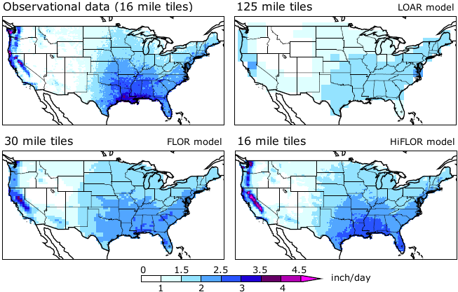
- Higher-resolution models significantly improve the simulation of mean precipitation, the distribution of precipitation, and spatial patterns, intensity and seasonality of precipitation extremes.
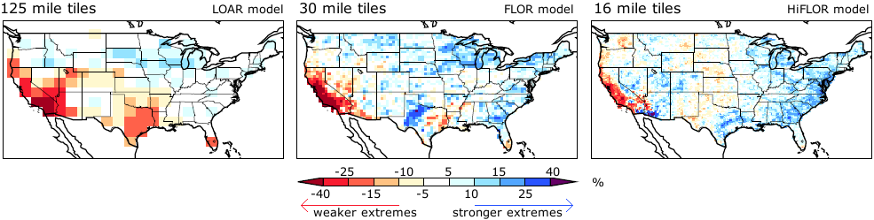
- All models show a mean intensification of precipitation extremes in response to CO2 forcing. Projected regional patterns of precipitation changes are dependent on model resolution.
- No changes in extreme precipitation attributable to climate change were found for the observational period, in large part because of significant year-to-year variability.
Karin van der Wiel, SB Kapnick, GA Vecchi, WF Cooke, TL Delworth, L Jia, H Murakami, S Underwood, F Zeng. Journal of Climate. DOI:10.1175/JCLI-D-16-0307.1
Summary
Precipitation extremes have a widespread impact on societies and ecosystems worldwide. Therefore, understanding current and future patterns of extreme precipitation is central to NOAA’s mission and highly relevant to society.
This study employed three newly developed global coupled climate models to study the impact of horizontal atmospheric model resolution (tile size) on precipitation extremes. Results show that higher-resolution models significantly improve the simulation of mean precipitation, the distribution of precipitation, and spatial patterns, intensity and seasonality of precipitation extremes. In response to 2xCO2 forcing, all models show a mean intensification of precipitation extremes, of approximately 3-4 %/K. The spatial pattern of changes depends on model resolution. For example, the two models with the highest resolution (FLOR and HiFLOR) show increased extreme precipitation during the Atlantic hurricane season in the U.S. southeast. In contrast, the low-resolution model (LOAR) does not show this change.
Given the different responses of high- and low-resolution models to CO2 forcing, the authors emphasize the importance of model choice for any study of extreme precipitation. There is a minimum model resolution that is needed to capture weather phenomena generating precipitation extremes, for example for simulating tropical cyclones or precipitation enhancement over mountains. As models approach this resolution, as FLOR and HiFLOR do, climate change projections can be made with more confidence.
The lowest-resolution model, LOAR, was designed to have a resolution similar to that of many models used for climate change projections in the latest IPCC report: 125×125 miles. The resolution was significantly increased in the FLOR model to 30×30 miles, a resolution at which tropical cyclones can develop. Finally, the HiFLOR model further increases the resolution to 16×16 miles.
The development of LOAR, FLOR and HiFLOR was enabled by years of Earth system research and model development at GFDL. This work was made possible by enhancements to NOAA’s research supercomputing capability including access to Gaea and Theia.