

OM4
OM4 is the ocean and sea-ice component of the physical climate model CM4, and earth system model ESM4. OM4 is a relatively new class of ocean model using a hybrid coordinate in the vertical direction, departing from the traditional depth coordinate of early climate models.
Key result
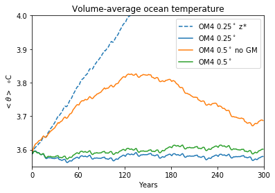
Use of the hybrid vertical coordinate in OM4 improves the conservation properties of the model and helps reduce spurious drift of the ocean state, thus also reducing spurious drift of the fully-coupled climate models. This result was highlighted in Fig. 8c (shown to the right) of the OM4 paper (Adcroft et al., 2019) which showed a strong dependence of ocean heat uptake on the choice of vertical coordinate in the ocean. It also demonstrates that the size of the spurious effect is comparable in scale to the role of large eddies that help move heat vertically in the ocean, emphasizing the need for better representation of these eddies either via parameterization or finer horizontal resolution.
Building blocks of OM4
Just as OM4 is one building block of CM4, OM4 is built for two main sub-components (MOM6 and SIS2) and replaces the atmosphere by data:
- MOM6 is the sixth version of the Modular Ocean Model that calculates the ocean circulation and distribution of heat and salt. MOM6 is novel for the implementation of general vertical coordinates using the Lagrangian-remap method (White et al., 2009; Griffies et al., 2020), that builds on the pioneering work of Bleck, 2002. Find out more about MOM6 on the GFDL ocean models page.
- SIS2 is the second version of the Sea Ice Simulator that calculates the evolutions of the sea ice that results from freezing sea water.
- The CORE-IAF reanalysis dataset is used to drive the ocean from above, providing winds, rain, snow, radiative fluxes and air temperature that add up to determine the fluxes of heat and water across the ocean surface (Griffies et al, 2016).
Concerning CMIP6 data: there are two resolutions of OM4 with nominal zonal resolution of ¼° (labelled OM4-0.25 in figure), used in CM4, and ½°, used in ESM4 (labelled OM4-0.5 in figure). In the CMIP6 database, OM4-0.25 appears with “source-id = GFDL-CM4, activity_id = OMIP”, and OM4-0.5 appears with “source-id = GFDL-OM4p5B, activity_id = OMIP”.
Related pages
CM4, ESM4. GFDL ocean models, The Modular Ocean Model
References
- Adcroft, Alistair, Whit G Anderson, V Balaji, Chris Blanton, Mitchell Bushuk, Carolina O Dufour, John P Dunne, Stephen M Griffies, Robert Hallberg, Matthew J Harrison, Isaac M Held, Malte Jansen, Jasmin G John, John P Krasting, Amy R Langenhorst, Sonya Legg, Zhi Liang, Colleen McHugh, Aparna Radhakrishnan, Brandon G Reichl, Anthony Rosati, Bonita L Samuels, Andrew Shao, Ronald J Stouffer, Michael Winton, Andrew T Wittenberg, Baoqiang Xiang, Niki Zadeh, and Rong Zhang, October 2019: The GFDL Global Ocean and Sea Ice Model OM4.0: Model Description and Simulation Features. Journal of Advances in Modeling Earth Systems, 11(10), DOI:10.1029/2019MS001726.
- Bleck, R., 2002: An oceanic general circulation model framed in hybrid isopycnic-Cartesian coordinates, Ocean Modelling, 4(1), p55-88, DOI:10.1016/S1463-5003(01)00012-9.
- Griffies, Stephen M., Gokhan Danabasoglu, Paul J Durack, Alistair Adcroft, V Balaji, C Böning, E P Chassignet, Enrique N Curchitser, J Deshayes, H Drange, B Fox-Kemper, P J Gleckler, Jonathan M Gregory, H Haak, Robert Hallberg, H T Hewitt, D M Holland, Tatiana Ilyina, J H Jungclaus, Y Komuro, John P Krasting, W G Large, S J Marsland, S Masina, Trevor J McDougall, A J George Nurser, James C Orr, A Pirani, F Qiao, Ronald J Stouffer, K E Taylor, A M Treguier, H Tsujino, P Uotila, M Valdivieso, Michael Winton, and Stephen G Yeager, September 2016: OMIP contribution to CMIP6: experimental and diagnostic protocol for the physical component of the Ocean Model Intercomparison Project. Geoscientific Model Development, 9(9), DOI:10.5194/gmd-9-3231-2016.
- Griffies, Stephen M., Alistair Adcroft, and Robert Hallberg, October 2020: A Primer on the Vertical Lagrangian‐Remap Method in Ocean Models Based on Finite Volume Generalized Vertical Coordinates. Journal of Advances in Modeling Earth Systems, 12(10), DOI:10.1029/2019MS001954.
- White, Laurent, Alistair Adcroft, and Robert Hallberg, December 2009: High-order regridding–remapping schemes for continuous isopycnal and generalized coordinates in ocean models. Journal of Computational Physics, 228(23), DOI:10.1016/j.jcp.2009.08.016.